


|
||

|

|
|

|
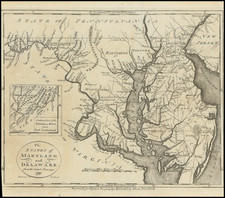
One of the earliest obtainable maps of the states. Shows counties, towns, roads, rivers, lakes, islands, harbors, bays, court houses, along with topographical details. The City of Washington is just now taking shape. Inset of the Continuation of the Potomac River from Fort Cumberland. Lewes appears as Lewiston. Clements Bay is shown on the Potomac in St. Mary's County. Potomac is spelled with a W on 3 occasions. Based upon Wayland Reid & Smith's map. Wheat & Brun 518. This map appeared in Volume IV of John Payne's New and Complete Universal Geography… published in New York by John Low at the Shakespeare Head, No. 332 Water-Street, in 1799. Following the publication of Carey's American Atlas in 1795, there were a small group of 18th Century works which included a complete set of state maps, including John Reid's American Atlas, Joseph T. Scott's Gazetteer, Carey's Pocket atlas and works by Jeddidiah Morse. This small group of maps and the few separately issued maps of the region, which are now virtually unobtainable, mark the beginnings of the indigenous cartographic publishing business in America, and are now highly soughtafter.


![(Civil War) Stanford's Map of the Seat of War in America. Sheet I. [Mid-Atlantic States]](https://storage.googleapis.com/raremaps/img/small/96007.jpg)
![[ Cape Hatteras to New York City ] The Coast of the United States of North America; from New York to St. Augustine: Drawn and regulated according to the latest Surveys and Astronomical Observations By Edmund Blunt. Additions to 1839 & 1840](https://storage.googleapis.com/raremaps/img/small/84684.jpg)
![[Right sheet only of: A New Chart of America Florida to New York with the Principal Harbours on a Large Scale, Drawn from the latest Authorities, by Robt Blachford. 1807.]](https://storage.googleapis.com/raremaps/img/small/55819.jpg)