|
||

|

|
|

|
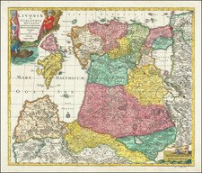
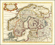
The Kingdom of Sweden in the Early 18th Century
Striking map of Scandinavia, the Baltic Sea, Lithuania, Latvia, Estonia, Curlandia, etc. with a large decorative title cartouche.
This attractively colored example of Johann Baptist Homann's circa 1716 map of the Kingdom of Sweden represents an updated portrayal of Sweden and its neighboring regions, reflecting the geopolitical shifts brought about by the Great Northern War (1700-1721). Homann likely based this map on Frederic de Wit's Regni Sueciae (1680), incorporating new details and place names that emerged during the war, such as the Russian capture of Kotlin Island and Nyenskans in 1703, and the founding of St. Petersburg. The city of Oresca (Oreshek), seized by Russia in 1702 and renamed Schlüsselburg by Peter the Great, is shown here under its former name.
This map was created during the Great Northern War between Sweden and Russia, a period marked by Sweden's territorial losses, especially around the Gulf of Finland and the newly established city of St. Petersburg. The engraved border between Russian and Swedish territories is retained from de Wit's 1680 Regni Sueciae Tabula Generalis, which delineated Sweden's acquisitions circa 1654. However, the detailed depiction of Karelia and Ingria on this map reveals the contested nature of these regions, many of which had been solidified as Russian by the map's publication. Livonia, Ingria, and Karelia are no longer depicted as Swedish, with St. Petersburg prominently marked.
The map features an attractive cartouche in the lower right corner, where two putti display the Swedish three-crowned arms, and a winged figure of Victory or Fame blows her horn overhead. Ares and Minerva observe from the side, symbolizing the lingering hope for Sweden despite Charles XII's devastating defeat at Poltava in 1709, which predates this map. The presence of a child with a plate of fish symbolizes the regions fishing culture.
Johann Baptist Homann (1663-1724) was a mapmaker who founded the famous Homann Heirs publishing company. He lived his entire life in Bavaria, particularly in Nuremberg. Initially, Johann trained to become a priest before converting to Protestantism and working as a notary.
In 1702, Johann founded a publishing house that specialized in engravings. The firm flourished, becoming the leading map publisher in Germany and an important entity in the European map market. In 1715, Johann was named Imperial Geographer to the Holy Roman Empire by Charles VI and made a member of the Prussian Academy of Sciences. Most importantly for his business, his reputation and contacts gained him imperial printing privileges which protected his publications and recommended him to customers. Johann is best known for this Grosser Atlas ueber die ganze Welt, or the Grand Atlas of the World, published in 1716.
After Johann died in 1724, the business passed to his son, Christoph (1703-1730). Upon Christoph’s early death, the company passed to subsequent heirs, with the name of the company changing to Homann Erben, or Homann Heirs. The firm continued in business until 1848.