This item has been sold, but you can enter your email address to be notified if another example becomes available.


|
||

|

|
|

|
Stock# 104460
Description
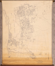
Large, folding wall map of San Diego at a scale of 1:24,000 issued by the U.S. Geological Survey in 1953, here printed in 1956.
The map provides exceptional detail, including building-level detail in some cases, of San Diego at the outset of the Postwar boom years.
Condition Description
Large color-printed wall map on a single sheet of mid-20th-century wove paper. Old folds with faint toning at folds. Minor soiling. Scant contemporary annotations.
![[Early Landsat Photograph of San Diego]](https://storage.googleapis.com/raremaps/img/small/90466.jpg)