The item illustrated and described below is sold, but we
have another example in stock. To view the example which
is currently being offered for sale, click the
"View Details" button below.


|
||

|

|
|

|
Stock# 55410
Description
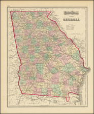
Gray's map of Georgia.
The map is colored by counties and showing townships, towns, villages, post offices, lakes, forts roads, railroads (projected and completed), Light Houses, Light Ships, etc.
A handsome map in attractive wash coloring. One of the best 19th Century maps of Georgia, from one of the last of the publishers who employed hand coloring.


![[ Revolutionary War Map Showing Rochambeau's March from Boston to the Chesapeake ]](https://storage.googleapis.com/raremaps/img/small/103560.jpg)