|
||

|

|
|

|
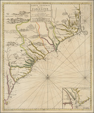
The First Obtainable Map of North Carolina. Rare on the Market.
A nice example of John Brickell's reduction of Edward Moseley's famed 1733 New and Correct Map of the Province of North Carolina map of North Carolina, issued in Brickell's book The natural history of North-Carolina... (1737).
The map is a cornerstone of any North Carolina collection, being the first obtainable map specifically of the colony. Moseley's map is generally regarded as being an unobtainable rarity.
Interestingly, Brickell's map differs from Moseley's in that it does not illustrate the North Carolina-Virginia border nor the North Carolina-South Carolina border. The North Carolina-South Carolina border was established with the Moseley map in 1737, so it is interesting that it does not show up in this map four years later.
Cumming (236) draws parallels between Brickell's book and map and those of John Lawson, whose A New Voyage to Carolina was published in London in 1709. This comparison is rather mistaken, as the far more important lineage is from that of Moseley.
Rarity
The map is almost never seen on the market individually; none of our databases nor online searches show it having been offered without the book. The book itself last sold at auction with the map at Christie's in 2017 for $12,500.
![[ North Carolina ] Neueste Karte von Nord Carolina mit seinen Canaelen, Strassen, Eisenbahnen, Entfernung . . . .1845](https://storage.googleapis.com/raremaps/img/small/89079.jpg)
![A New and Exact Map of the Dominions of the King of Great Britain on ye Continent of North America . . . [Beaver map]](https://storage.googleapis.com/raremaps/img/small/101277.jpg)